
Explained: The strategic road to DBO
In the reporting on the LAC stand-off, the Darbuk-Shyok-Daulat Beg Oldie (DSDBO) road has often appeared. What is this all-weather road built by India over nearly 20 years, and why does it matter?
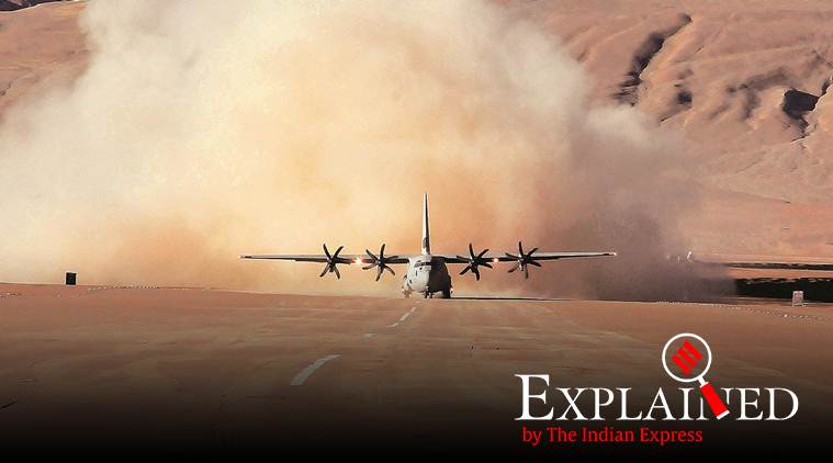 IAF C 130J-30 super Hercules makes a historic landing at Daulat Beg Oldie (DBO) on August 20, 2013. (Archive photo)
Of the possible triggers cited for the People’s Liberation Army’s (PLA) targeting of Indian territory along the Line of Actual Control (LAC) in eastern Ladakh, the construction of the 255-km long Darbuk-Shyokh-Daulat Beg Oldie (DSDBO) all-weather road is possibly the most consequential.
Running almost parallel to the LAC, the DSDBO road, meandering through elevations ranging between 13,000 ft and 16,000 ft, took India’s Border Roads Organisation (BRO) almost two decades to construct.

Its strategic importance is that it connects Leh to DBO, virtually at the base of the Karakoram Pass that separates China’s Xinjiang Autonomous Region from Ladakh.
DBO is the northernmost corner of Indian territory in Ladakh, in the area better known in Army parlance as Sub-Sector North.
DBO has the world’s highest airstrip, originally built during the 1962 war but abandoned until 2008, when the Indian Air Force (IAF) revived it as one of its many Advanced Landing Grounds (ALGs) along the LAC, with the landing of an Antonov An-32.
READ | Experts Explain: What triggered China’s recent LAC moves?
In August 2013, the IAF created history by landing one of its newly acquired Lockheed Martin C-130J-30 transport aircraft at the DBO ALG, doing away thereafter with the need to send helicopters to paradrop supplies to Army formations deployed along the disputed frontier.
Defence Minister Rajnath Singh has acknowledged that “large numbers” of Chinese troops had massed along the LAC, and had “come a little further than they used to earlier”, making the situation “different” this time from earlier incidents between the two sides in the same region.
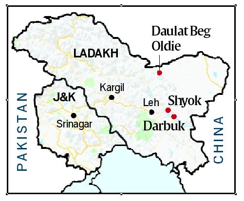
The Chinese build-up along the Galwan River valley region overlooks, and hence poses a direct threat to the DSDBO road.
The token mutual de-escalation of the two armies, ahead of a series of bilateral consultations between senior military and other officials, is expected to be completed over an extended period. The withdrawals are subject to reciprocal endorsement.
***
The DSDBO highway provides the Indian military access to the section of theTibet-Xinjaing highway that passes through Aksai Chin. The road runs almost parallel to the LAC at Aksai Chin, the eastern ear of erstwhile Jammu and Kashmir state that China occupied in the 1950s, leading to the 1962 war in which India came off worse.
Explained: What does the increase in Chinese transgressions mean?
The DSDBO’s emergence seemingly panicked China, evidenced by the 2013 intrusion by the PLA into the nearby Depsang Plains, lasting nearly three weeks.
DBO itself is less than 10 km west of the LAC at Aksai Chin. A military outpost was created in DBO in reaction to China’s occupation of Aksai Chin, and is at present manned by a combination of the Army’s Ladakh Scouts and the paramilitary Indo-Tibetan Border Police (ITBP). Both forces regularly patrol the LAC.
There are additional strategic considerations in the area.

To the west of DBO is the region where China abuts Pakistan in the Gilgit-Baltistan area, once a part of the erstwhile Kashmir principality.
This is also the critical region where China is currently constructing the China-Pakistan Economic Corridor (CPEC) in Pakistan-Occupied Kashmir (PoK), to which India has objected.
As well, this is the region where Pakistan ceded over 5,180 sq km of PoK to China in 1963 under a Sino-Pakistan Boundary Agreement, contested by India.
📣 Express Explained is now on Telegram. Click here to join our channel (@ieexplained) and stay updated with the latest
***
What makes the DSDBO an “all-weather” road is the 37 prefabricated military truss bridges along it. Previously an old road, largely a track, existed along the same alignment as the pucca road, but was practically unusable during summer due to the flooding of the snow-fed Shyok river – or River of Death – and its tributaries, including the Chip Chap, Galwan, and Chang Chenmo that crisscross it.

The Shyok river itself is a tributary of the Indus, flowing through northern Ladakh and Gilgit-Baltistan. It eventually re-joins the Indus at Keris, east of Skardu.
In October 2019, Defence Minister Singh inaugurated a 500-m-long Bailey Bridge on the road. The bridge is named after Colonel Chewang Rinchen, an Indian Army hero from Ladakh. Located at 14,650 ft, it is believed to be the world’s highest such bridge.
An alternative route exists from Leh to Daulat Beg Oldie through the 17,500-ft-high Sasser Pass that was part of the ancient Silk Route connecting Leh to Yarkand. It leads from the Nubra Valley into the Upper Shyok Valley en route to China’s Karakoram Pass, indicating the topographical and strategic interlinking of the entire disputed region between India and China and to a lesser extent, Pakistan.
In Pictures | Satellite images show situation along Line of Actual Control
For most of the year bar a few summer months, Sassar La — or pass — is snow-bound and inaccessible. The BRO is currently building a “glaciated road” between Sasoma (north of Leh, near the Nubra river) to the Sasser Pass, but it could take several years to complete. But even when it is, the alternate DBDSO will remain critical to the Army and its defences in the region.

 Share
Share


